
Beaumont's Rising Fortunes
By John Gibb, on Saturday 11 January 2014
Otago Daily Times
Moves are afoot to make the small Otago township of
Beaumont the thriving community it once was. John Gibb finds
out about Beaumont's changing fortunes.
Once a fading rural backwater, the township of Beaumont now
seems destined for a much brighter future.
People who have lived near the inland Otago township, on the
Clutha River/Mata-au, for 20 years or more will remember
earlier sometimes divisive and frustrating conflicts over
proposed big hydro-electric dams, which would have flooded
the area.
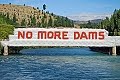
One proposal, by the Electricity Corporation of New Zealand
(ECNZ) in 1992, was to build a dam at Tuapeka Mouth that
would have flooded 3000ha, including all of Beaumont. But
among a series of more promising developments the
long-delayed replacement work involving the nearby 19th
century Beaumont Bridge is at last due to start next year.
This is one of the oldest bridges in the country still
operating on a major state highway.
And more walkers and cyclists are already starting to move
through the township since the 73km-long Clutha Gold Trail-
which runs between Roxburgh and Lawrence, and includes
Beaumont- was opened by Prime Minister John Key on October
24. Long-time resident, historian and writer Bill Dacker (61)
is well aware of the area's previously somewhat mixed
fortunes.
''It was a little backwater that we enjoyed as a backwater,''
he recalls.
But then a series of dam proposals came along and changed
everything, he said.
Some locals, including some facing tough economic times, had
agreed to sell their land.
Others, including the ''Hands Off Beaumont'' lobbyists, were
determined to resist and to safeguard all they found precious
in the area, including its rich history and its attractive
and distinctive environment.
Mr Dacker highlights the significance of the bridge
replacement work.
The current bridge had been around since 1887 and had
struggled to cope with some of the ''huge trucks'' now
passing through.
Mr Dacker, who is a long-standing member of the Clutha Gold
Trail Trust Board, says the newly opened trail and other
developments mean brighter times are coming for Beaumont,
which will boost the local economy by bringing in more
visitors and potential new residents. Strengthening Beaumont
was also important strategically, because it gave the area a
better chance of influencing its own destiny in future, he
said.
''Unless we're going to make the place strong in a different
way, other people are [still] going to see it as a
backwater,'' he says.
Dave Crawford is an experienced jet boater and
co-owner-operator of Beaumont Jet, with his wife Ali, And he
is also a Gold Trail board member.
It was ''great'' to see the cyclists already starting to flow
along the track, through Beaumont.
''It can only be good for this area,'' he says.
When he and his wife moved to Beaumont and began jet boat
operations in 2004, he had long known the area had strong
potential.
The nearby Clutha River/Mata-au is ''probably the best part
of the Clutha River'', he adds.
These stretches of the river were also as good as ''anything
in New Zealand'' and offered plenty of variety, including
''huge rapids'' and other ecologically appealing areas.
And he is not content with Beaumont being one of the region's
and New Zealand's best-kept secrets.
''The more people the better.''
Mr Dacker, who these days divides his time between Beaumont
and Port Chalmers, has lived in Beaumont for much of his
life, having grown up there.
His father, Harry Dacker, had initially found work there as a
rabbiter in the 1920s.
Bill Dacker said the idea of building a''cycle-cum-walking
trail through the district, along the river and through the
farmland to Lawrence, was a direct response - a way of
creating economic opportunity by bringing people into this
area as well as the other areas connected by the trail''.
The idea had come from the trust's Roxburgh-based chairman,
Rod Peirce, who was a ''retired orchardist from Millers Flat
with long-standing connections in Beaumont as well as to the
other communities along the trail.''
The lessees of the Beaumont Hotel had also contributed to the
upturn in Beaumont's fortunes by continuing to develop and
support ''events tailored to hunters and fishermen while
adding cyclists to those they wish to give hospitality to''.
And the pub also served ''the best blue cod meals this side
of Iceland'', Mr Dacker said.
Widespread support from the Beaumont community for the trust,
as well as backing from ''other communities connected by the
trail'', had been key to the success of the trail
development.
This sense of unity and support stood in ''stark contrast to
divisions in the communities'' sparked by the ECNZ dam
proposal in 1992, and was ''a wonderful thing to
experience''.
Alison Mills, who leases the hotel with her husband, Gunni
Egilsson, is also optimistic about the future, and says
patrons with different interests and from range of
backgrounds, including tourists, were using the hotel and
nearby camping ground.
Mr Dacker noted there had been some ''recent controversy''
over suggestions of fees for using the trail.
He emphasised there was no official fee for using it, ''but
the trust asks for a koha [donation], a contribution for its
maintenance from its users as at the moment the trust is
solely responsible for costs of its maintenance''.
Mr Peirce (76) said there were early signs that the new trail
would prove positive, and help revive smaller communities
such as Beaumont and Millers Flat.
''It's very satisfying. There's a general air of
enthusiasm.''
Mr Peirce, who was also once chairman of the Friends of
Beaumont group, had opposed various proposals to establish
big new dams nearby.
And he is positive about the new trail's benefits.
''I thought, if there's any legacy I can leave, it may well
be more like the trail, which is more positive, rather than
being an activist against everything.
''I'd like to be seen as someone who left something for the
benefit of the community.''
People were already starting to come from far afield to ride
or walk the new trail, and local families were also enjoying
it.
''We've had a tremendous amount of support from Contact
Energy.''
And $3.8 million from the Government's New Zealand Cycle
Trail project funding had been used to support the trail's
development. Through the years Mr Peirce has noticed rural
decline, including loss of population and services, in some
of the smaller communities.
''It's very positive. I think that the smaller villages will
definitely gain a tremendous amount over the next several
years and into the future from the trail.''
And Beaumont was already looking up. The school had closed
some decades ago, but ''rural visitors'' were increasing and
the pub was humming - ''it's quite a busy little pub'', Mr
Peirce said.
The gold trail was also good for Millers Flat - ''it's the
only town that the trail actually goes right through the
middle of.''
And Mr Dacker highlights Beaumont's distinctive geographical
position, and its historical significance.
Beaumont is the first crossing place of the Clutha
River/Mata-au when travelling on SH8 from Milton to Central
Otago, and its many attractions. And the area was ''one of
the major entrance and exit points'' for the Clutha Gold
Trail walkway.
The Clutha River/Mata-au is one of the outstanding natural
features of the newly opened trail, which follows the river
''on its journey across the river flats below Roxburgh,
through the Beaumont Gorge, before it turns toward Lawrence
at Beaumont'', Mr Dacker says. The river crosses the Beaumont
Flat and then passes through the Rongahere Gorge, the ''last
major river flat and gorge respectively of the schist
peneplain or block mountain system of the Central Otago
highlands''.
Beaumont was a true border between very different
geographical zones.
''On the Rongahere side the climate is wetter and cooler,
more like that of coastal Otago than Central Otago. On the Beaumont Gorge side the climate is hotter and drier,
marking the beginning of Central Otago proper.''
The Maori name for the district is Te Kohai and here the
ancestors of Kai Tahu Whanui also crossed the river, but on
mokihi (traditional rafts), on their journeys into the
interior.
There was also once a moa-hunting era village at Beaumont.
The town of Beaumont grew around the river crossing, where a
ferry operated, accompanied by a supporting structure of
hotels and shops. The natural vegetation of the nearby gorges
reflected the ''borderland'' characteristics.
The dominant tree on Upper Birch Island - also known locally
as Native Island - in the Beaumont Gorge is mountain beech,
indicating the drier and hotter conditions there. The far
larger Birch Island, or Moanui, in the Rongahere Gorge below
Beaumont, and the bush of the gorge itself, has a covering of
a mixed podocarp forest that includes sphagnum moss, mountain
and silver beech as well as totara and matai.
''Both the gorge and the island are home to rare and nearly
extinct insect species, protected on the island from rat
predation by the swift waters of the river,'' Mr Dacker says.
''Beaumont's fortunes have fluctuated over the years
according to major changes in the economic, gold-mining and
agricultural history of the province.''
First the search for gold, then the arrival of the railways
and the rise of horticulture on the river flats of Central
Otago followed by the development of exotic forest
plantations in the Blue Mountains all contributed to its
growth.
But, subsequently, the closure of the railway branch line,
the decline in gold extraction, the rise of large land
holdings, changes in the horticultural sector, and finally
the closure of the Beaumont Forest headquarters had also
contributed to the community shrinking.
Closures of the railway, shops, the race track, churches and
the school had all followed ''but always a significant
minority clung on'' and many people, including some who had
left, showed ''a remarkable dedication to the area'', Mr
Dacker said.
And he emphasises that, for the first time in 40 years, there
were ''signs of growth at Beaumont again''.
Margaret Healy, who helped organise a series of ''Back to
Beaumont'' days, held over the years, has always been
optimistic about the township's future.
''The aim is to get people and their families to come back to
their grassroots, reminisce and enjoy Beaumont,'' she said.
It was a great place to raise a family and she was keen for
Beaumont to become a ''thriving community'' again.
Beaumont
• Beaumont is a township on State Highway 87, at a crossing of the Clutha Mata-Au River, close to Central Otago, between Balclutha and Roxburgh, and is 6km southeast from Raes Junction.
• The township is one of the main entry and exit points on the 73km-long Clutha Gold Trail, between Lawrence and Roxburgh.
• The gold trail's development was backed by $3.8 million in New Zealand Cycle Trail project funding and was opened by Prime Minister John Key in October.
• The trail includes parts of an old Maori trail, sections of the former railway line route, and parts of a former road.
• An earlier proposal in 1992 by ECNZ was to build a dam at Tuapeka Mouth that would have flooded several thousand hectares, including all of Beaumont.


0 comments:
Post a Comment